ABOUT THE PROJECT
___________
At the EU level, timber harvesting is increasing to meet the higher demand for bioenergy and the bioeconomy. At the same time, demands associated with climate mitigation, nature conservation, recreation and other non-wood ecosystem services (ES) are becoming increasingly important. These increasing yet sometimes conflicting demands towards forests can lead to conflicts in forest use among different stakeholders. Forest management planning is an important tool for designing and implementing management interventions for providing a set of various ecosystem services (ES). The proposed research project (IFORPLAN) introduces novel approaches related to spatial forest planning.

iForplan project aims to achieve the following:
- develop a procedure for the zonation of the forest landscape into ES priority areas differing in their capacity to supply ES;
- establish a system of ES indicators and integrate them into forest planning by using quantitative and qualitative MCDA methods;
- create a procedure for defining climatesmart forest management strategies with respect to their capacity to supply ES; and
- engage in collaborative modelling with stakeholders in the zoning of ES priority areas, selecting ES indicators and defining climate-smart management interventions.
The project focuses on five prevailing ES: timber, protection, nature conservation, recreation and carbon sequestration. In each participating country (Estonia, Finland, Poland and Slovenia), a case study forest area of a few thousand hectares is selected to test the developed procedures related to ES priority areas, ES indicators and climate-smart management strategies. Participatory methods will be integrated throughout the project to evaluate novel planning procedures from both a scientific perspective and practitioner expectations.
The project aims to enhance understanding of multifunctional forest management and contribute to the implementation of Sustainable Development Goals.
Project scheme
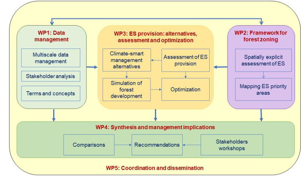
WP1 Data management, concepts and definitions
In this WP we will 1) identify possible stakeholders; 2) gather, harmonize and filter data provided by project partners within the whole period of project; and 3) provide clear definitions of key terms and concepts applied in the project. Data framework from this package will be base for:
- WP2 forest zoning,
- WP3 assessing the current status of ecosystem services in the study areas,
- WP3 simulating stand/forest development.
Geographic information systems will be used for all study areas with raster and vector data derived either from private or public databases.
WP2 Framework for forest zoning
In cooperation with experts, the research group will develop 1) indicators and methods for evaluating ES supply, demands and flow in forest area, and 2) a procedure for designating priority areas for the selected ES. ES assessment will be defined based on selected indicators describing the supply, demand and flow of each ES. The ES assessment will be performed based on GIS raster layers. The novel framework will be used while considering the specifics of each country (e.g. legislation rules, specific social and natural conditions).
The following five main ES will be studied: timber production, forest protection, carbon management (stock and sequestration), nature conservation and maintenance of biodiversity, recreation. Priority areas will be designated by the aggregation of cells based on prioritization rules developed in the project team. Areas with no priority ES will be considered as “other multifunctional forests”. Visualisation of priority maps with the assessment of ES supply and demand are an important basis for selecting appropriate management strategies that support the stable provision of the desired ES.
WP3 Evaluation of the effect of forest zoning and climate-smart management on the levels of ES indicators
This WP will evaluate the effectiveness of ES priority areas (defined in WP2) and climate-smart forestry options based on their potential capacity to supply sustainable levels of ES in the partner countries. We will conduct new simulations with optimization to select the climate-smart forestry options which best supply each ES and overall forest multifunctionality both in ES priority areas and in the whole forest landscape.
WP4 Synthesis and management implications
The overall results of the research will be synthesized into a coherent understanding of multifunctional and climate-smart forest management planning. Specifically, various approaches used to derive forest zones and silvicultural regimes employed across case study areas will be put together to assess the ability of the approaches to operationalize multifunctional forest management. The implications of stakeholders preferences, scientific requirement, forest policies and regulations in different EU settings will be interpreted for synergistic use of the knowledge in pan-European forest management planning.
WP5 Project coordination and dissemination of the results
This WP is dedicated to interactions among project partners and dissemination of project outcomes. A kick-off meeting and final meeting will be organised. In addition, participatory meetings will be organised for stakeholders (one in each participating country), where outcomes of the project (results of WP2 and WP3) will be presented, and then discussed and evaluated by stakeholders (WP4).
STUDY SITES
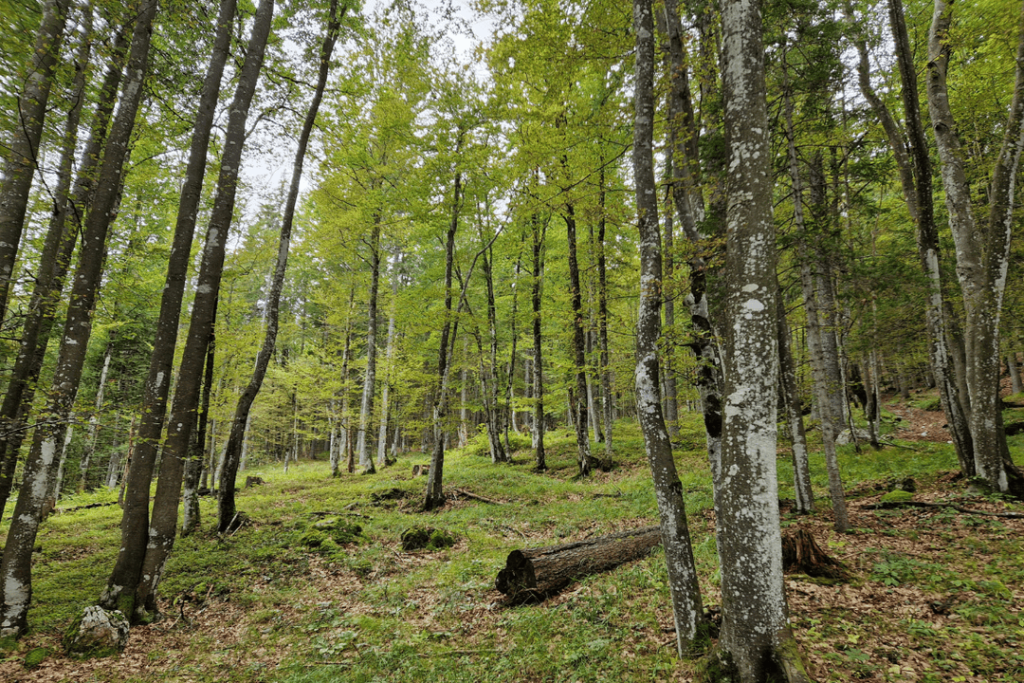
Kranjska Gora, Slovenia
The Kranjska Gora management of Slovenia Forest Service is located in the most north-western part of Slovenia. Its 9000 ha of forests is both private and state owned. It is a highly diverse forest area with many ecosystem services including production, protection, biotopic function, tourism and others. The northern part emphasizes production forestry, while the southwestern part has protective and biotopic functions, including areas within Triglav National Park. The site spans elevations from approximately 800 to 2,000 meters, hosting varied forest types, primarily Norway spruce-European beech-silver fir stands.
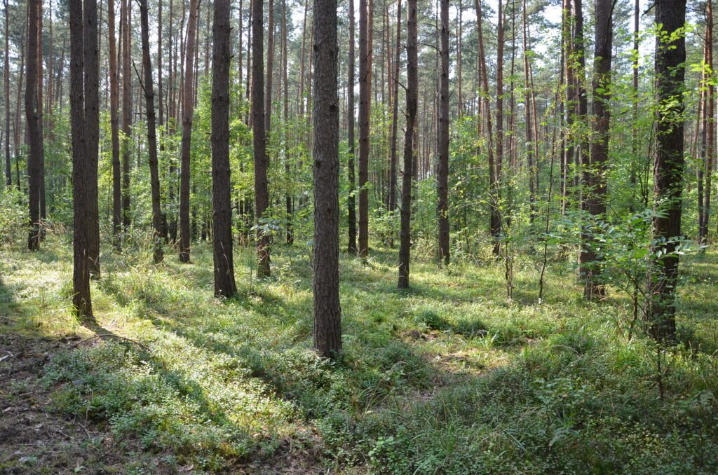
Zielonka Forest Districts, Poland
The Zielonka Forest Districts, located in Poland, encompass 9,500 hectares of university experimental forests. These lowland subboreal forests are characterized by mixed coniferous and broadleaved stands, with Scots pine being the predominant tree species. The forests are managed to support a variety of functions, including research, production, recreation, and conservation. The site is extensively documented permanent circular sample plots and inventory data for forest stands.

Koorküla, Valga county, Estonia
The Koorküla forest area is located in Valga County, Estonia, and covers approximately 6,000 hectares of both private and state-owned forests. This hemiboreal forest landscape features diverse forest types, including Scots pine, Norway spruce, and silver birch forests. Detailed stand-wise inventory data is available, complemented by permanent sampling plots. The site is supported by other datasets, including topography, soil types, and Natura 2000 conservation statuses.
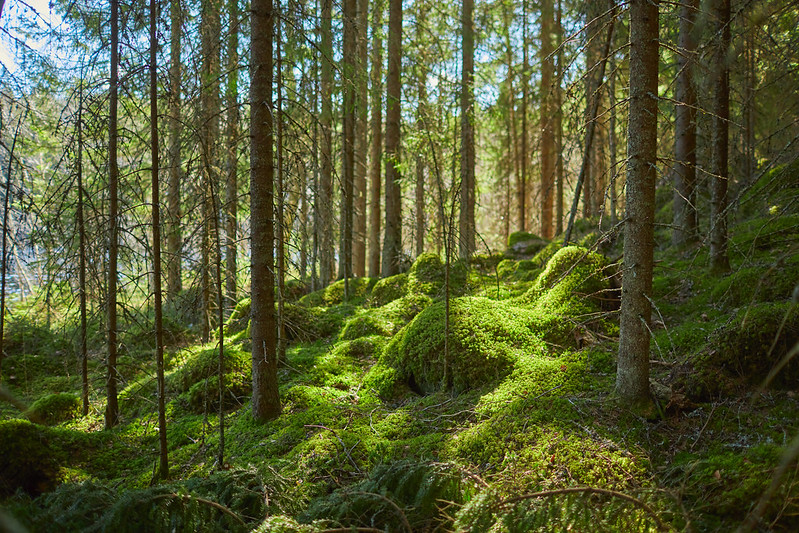
Evo hiking area, Finland
The Evo Hiking Area, located in Southern Finland within the Hämeenlinna and Padasjoki regions, spans approximately 4,700 hectares. Established in 1994, it is one of the largest continuous forested areas in Southern Finland. The landscape features a diverse mix of dry pine forests, ridges, and lakes and ponds. These boreal forests are dominated by Norway spruce and Scots pine. The area is managed collaboratively by three organizations: Metsähallitus, Parks & Wildlife Finland, ensuring sustainable use and conservation of natural resources; HAMK University of Applied Sciences, managing a portion of the area as a teaching forest; The City of Hämeenlinna.


Innovative spatial forest planning for supporting resilient multifunctional forest management
COORDINATION
University of Ljubljana,
Biotechnical faculty,
Department of forestry and renewable forest resources
Večna pot 83, SI-1000 Ljubljana